集信:DJI 0550-HDR-Pano.jpg
戟𡱩形䀡𠓀:800×511點影。 度分解恪:320×205點影 | 640×409點影 | 1.024×654點影 | 1.280×818點影 | 2.560×1.636點影 | 6.651×4.251點影。
集信㭲 (6.651×4.251點影、戟𡱩集信:22,58 MB、矯MIME:image/jpeg)
集信尼得留於威其迷𠫾阿・古門吧伮固体得使用於各預案恪。 𠳒描寫𧵑集信在張模寫得顯示𨑜低。
Summary
DescriptionDJI 0550-HDR-Pano.jpg |
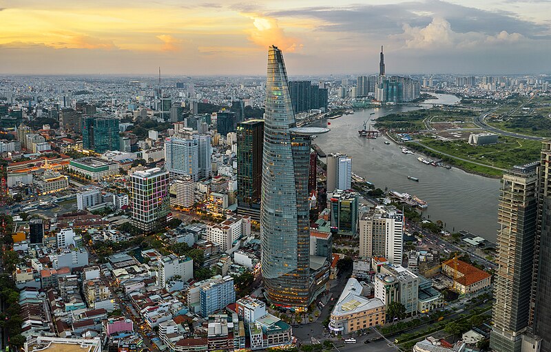
English: Downtown Saigon and Saigon River |
|||
Date | ||||
Source | https://www.flickr.com/photos/leminhphat/48548518557/ | |||
Author | Lê Minh Phát | |||
Other versions |
|
Camera location | 10° 46′ 08.44″ N, 106° 42′ 12.18″ E | View this and other nearby images on: OpenStreetMap | 10.769011; 106.703384 |
---|
Licensing
This file is licensed under the Creative Commons Attribution 2.0 Generic license.
- You are free:
- to share – to copy, distribute and transmit the work
- to remix – to adapt the work
- Under the following conditions:
- attribution – You must give appropriate credit, provide a link to the license, and indicate if changes were made. You may do so in any reasonable manner, but not in any way that suggests the licensor endorses you or your use.
This image was originally posted to Flickr by Phat110592 | 0905462002 at https://flickr.com/photos/69057165@N07/48548518557. It was reviewed on 3 September 2022 by FlickreviewR 2 and was confirmed to be licensed under the terms of the cc-by-2.0. |
3 September 2022
Items portrayed in this file
depicts
Some value without a Wikidata item
26 July 2019
10°46'8.440"N, 106°42'12.182"E
0.01 second
3.2
10.26 millimetre
100
image/jpeg
3216ce7463eafa896b1d5b36fa7f5f842fe577d1
23673751 byte
4251 pixel
6651 pixel
歷史集信
扨𠓨𣈜/𣇞抵䀡內容集信在時點妬。
𣈜/𣇞 | 形䀡𠓀 | 戟櫸 | 成員 | 描寫 | |
---|---|---|---|---|---|
現在 | 03:32、𣈜16𣎃10𢆥2023 | 6.651×4.251 (22,58 MB) | wikimediacommons>Đại Việt quốc | Reverted to version as of 13:24, 3 September 2022 (UTC) |
張使用集信
張𢖖󠄁使用集信尼:
特性形
集信尼貯通信補充、固体得添自𣛠影技術數或𣛠𢭯得使用抵造或數化𣜿。
裊集信㐌得𢯢𢷮𬧺貝狀態班頭、𠬠數枝節固体空反映𣹓𨁥集信㐌𢯢𢷮。
Camera manufacturer | Hasselblad |
---|---|
Camera model | L1D-20c |
Exposure time | 1/100 sec (0,01) |
F Number | f/3,2 |
ISO speed rating | 100 |
Date and time of data generation | 18:17、𣈜26𣎃7𢆥2019 |
Lens focal length | 10,26 mm |
Latitude | 10° 46′ 8,44″ N |
Longitude | 106° 42′ 12,18″ E |
Altitude | 246,8 meters above sea level |
Orientation | Normal |
Horizontal resolution | 300 dpi |
Vertical resolution | 300 dpi |
Software used | Adobe Photoshop CC 2018 (Windows) |
File change date and time | 09:53、𣈜16𣎃8𢆥2019 |
Exposure Program | Manual |
Exif version | 2.31 |
Date and time of digitizing | 18:17、𣈜26𣎃7𢆥2019 |
APEX shutter speed | 6,643856 |
APEX aperture | 3,356144 |
APEX exposure bias | −1,3 |
Maximum land aperture | 2,971 APEX (f/2,8) |
Metering mode | Center weighted average |
Light source | Unknown |
Flash | Flash did not fire |
DateTimeOriginal subseconds | 11 |
DateTimeDigitized subseconds | 11 |
Color space | Uncalibrated |
File source | Digital still camera |
Scene type | A directly photographed image |
Exposure mode | Manual exposure |
White balance | Auto white balance |
Digital zoom ratio | 1 |
Focal length in 35 mm film | 28 mm |
Scene capture type | Standard |
Scene control | None |
Contrast | Normal |
Saturation | Normal |
Sharpness | Normal |
GPS tag version | 0.0.3.2 |
Serial number of camera | 0K8TFBH0021337 |
Lens used | 28.0 mm f/2.8 |
Date metadata was last modified | 16:53、𣈜16𣎃8𢆥2019 |
Rating (out of 5) | 0 |
Unique ID of original document | 9AD20F6193684BAA275CC7477C388B57 |