
集信:Antpen-en.png

戟𡱩形䀡𠓀:388×600點影。 度分解恪:155×240點影 | 310×480點影 | 497×768點影 | 1.025×1.584點影。
集信㭲 (1.025×1.584點影、戟𡱩集信:1.021kB、矯MIME:image/png)
Summary
| Description |
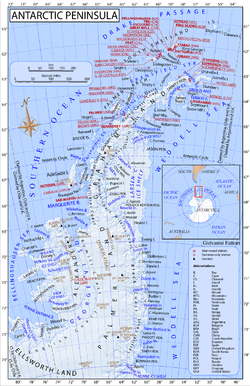
English: Map of Antarctic Peninsula, stations locations, shared relief. Projection Equidistant conic B. S. parallel 1:-65. S. Parallel 2:-71. Central meridian:-62. Shared relief from NASA data |
| Date | |
| Source | Own work |
| Author | Gi |
Licensing
I, the copyright holder of this work, hereby publish it under the following license:
This file is licensed under the Creative Commons Attribution-Share Alike 3.0 Unported license.
- You are free:
- to share – to copy, distribute and transmit the work
- to remix – to adapt the work
- Under the following conditions:
- attribution – You must give appropriate credit, provide a link to the license, and indicate if changes were made. You may do so in any reasonable manner, but not in any way that suggests the licensor endorses you or your use.
- share alike – If you remix, transform, or build upon the material, you must distribute your contributions under the same or compatible license as the original.
歷史集信
扨𠓨𣈜/𣇞抵䀡內容集信在時點妬。
| 𣈜/𣇞 | 形䀡𠓀 | 戟櫸 | 成員 | 描寫 | |
|---|---|---|---|---|---|
| 現在 | 20:43、𣈜23𣎃8𢆥2011 | | 1.025×1.584 (1.021kB) | wikimediacommons>Gi |
張使用集信
張𢖖󠄁使用集信尼: